
Copyright ©APK4Share. All Rights Reserved
应用和Jugnoo Drivers, Lalamove Driver - Earn Extra Income, GPS Emulator Pro APK v1.59 MOD APK, Genius Maps Offline GPS Navigation, Hammer Truck GPS Navigation App, Maps, & Routes, Circuit Route Planner一样好,TouchTrails - Route Planner, GPX Viewer/Editor - v2.2.1也很多,是类型地图和导航中最出色的应用之一。
由pixelclash开发,TouchTrails - Route Planner, GPX Viewer/Editor - v2.2.1至少需要Android版本Android 5.0+。因此,如有必要,您必须更新手机。
TouchTrails - Route Planner, GPX Viewer/Editor - v2.2.1 APK的最新版本为2.2.1,发行日期为2020-11-17,大小为17.1 MB。
有关1000下载的统计信息可从Google Play获得。您可以根据需要更新已单独下载或安装在Android设备上的应用。更新您的应用可以为您提供更多功能。您可以访问最新功能并提高安全性和应用程序的稳定性。
由于并非所有游戏或应用程序都兼容所有手机。并且游戏或应用程序不适用于您的设备,因此取决于Android OS版本,屏幕分辨率或Google Play允许访问的国家/地区。因此,通过APK4Share,您可以轻松下载APK文件,不受这些限制。
TouchTrails is an easy to use route planner. Measure the distance of your last running activity or explore the elevation profile of the next bike tour you are planning to do. Just draw it on the map and get the information you're looking for.
TouchTrails is the perfect route planner for all kind of outdoor activities, including:
• Hiking
• Cycling
• Mountain Bike
• Running
• Walking
• Mantrailing
With this route planner you can simply draw routes with your finger on the map. Get distance information and elevation profiles even for the smallest footpaths and trails in the backcountry.
You can split tracks, erase parts of a track or connect routes. Export your routes as GPX, share them and open them wherever you want to.
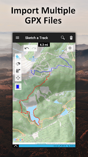
GPX Viewer
You can also use TouchTrails as a simple GPX viewer. Import gpx files for your hiking tour or whatever outdoor activity you plan to do. Multiple routes will be displayed in different colors. Measure distances and view elevation profiles.
Features
• Route planner - draw routes with finger
• GPX Viewer - import GPX files
• Explore elevation profiles
• Calculate distances
• Manage and merge multiple routes
Pro Features
• Save as many tracks as you want
• Export gpx files
• Generate offline maps for your backcountry trip
Install TouchTrails–the route planner at your fingertip–to plan your next hiking or mountain bike tour on a small footpath in the backcountry now ?.
• New map provider: faster and more reliable maps
Show moreRELATED