
Copyright ©APK4Share. All Rights Reserved
应用和Radarbot (MOD, Premium 已解锁) MOD APK, Relief Maps - 3D GPS Hiking | Trail Running | Ski, Lalamove Driver - Earn Extra Income, Circuit Route Planner, Bykea Partner, Genius Maps Offline GPS Navigation一样好,NavShip - Boat Navigation (USA & Europe) - v1.31.1也很多,是类型地图和导航中最出色的应用之一。
由CproSoft GmbH开发,NavShip - Boat Navigation (USA & Europe) - v1.31.1至少需要Android版本Android 4.1+。因此,如有必要,您必须更新手机。
NavShip - Boat Navigation (USA & Europe) - v1.31.1 APK的最新版本为1.31.1,发行日期为2021-02-17,大小为21.5 MB。
有关1000下载的统计信息可从Google Play获得。您可以根据需要更新已单独下载或安装在Android设备上的应用。更新您的应用可以为您提供更多功能。您可以访问最新功能并提高安全性和应用程序的稳定性。
由于并非所有游戏或应用程序都兼容所有手机。并且游戏或应用程序不适用于您的设备,因此取决于Android OS版本,屏幕分辨率或Google Play允许访问的国家/地区。因此,通过APK4Share,您可以轻松下载APK文件,不受这些限制。
Best for inland waterway routing! Please note, that some rivers and seas might not be included yet. Please use the contact form inside the app menu (report error at the bottom) to request a new waterway, and we will implement them as soon as possible.
Free version: Up to 40 km (25 miles) route planning and 8 km tracking. We use advertisement in free version.
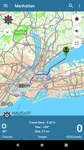
NavShip is a free navigation assistance software for nautic usage in Europe, Canada and the United States. It uses an special overlay for google maps or open sea map to show shipping signs and contains by now more than 250.000 waterways.
No problem to get from A to B, even if there's an ocean between you and your target. London - Rome, Paris - Amsterdam, Copenhagen - Stockholm, Frankfurt - Istanbul, Chicago - Toronto, nearly every route can be calculated.
NavShip needs access to device's storage to work properly. It never accesses your private data or contacts.
WEAR OS: NavShip provides a Wear OS App for Smartwatches. You can easily connect with live routing on your app. Calculate a route on your smartphone and view your current speed, course offset, distance and travel time via smartwatch. Even the next bridge or lock will be displayed.
Features:
Offline-Routing
Live-Routing
Kilometres or miles, km/h or knots
Travel time and distance
Approx. arrival time
Course and speed over ground
Locks
Fuel and costs
Anchor alert
Implementation of own boat icon for routing
Lots of more...
Get more information at www.navship.org
Disclaimer: This app should only be used as an assistant. Please use it carefully and supportive. NavShip is not responsible for accidents. Please note the in app disclaimer and the terms of use at navship.org.
Added side menu entry for privacy policyNew menu entry to swap start and finishCurrents in bodies of water are taken into account if it has been activated in the app settings (currently only for Rhine, Main, Neckar, Mosel, Waal, Lek, IJssel, Maas, Odra, Weser, Elbe, Lahn, Danube and Ems)The app warns when the current of a river is greater than the maximum speed of the boatAdded new compass imageUpdated translations
Show moreRELATED