Copyright ©APK4Share. All Rights Reserved
Download Geo Survey - v1.1
| Package Name | com.ncbc.survey.gis |
|---|---|
| Category | APPS, Map & Navigation |
| Latest Version | 1.1 |
| Get it On |

|
| Update | February 08, 2021 (4 years ago) |
There are quite a few APPS as good as Genius Maps Offline GPS Navigation, Jugnoo Drivers, Circuit Route Planner, Relief Maps - 3D GPS Hiking | Trail Running | Ski, Bykea Partner, Radarbot (MOD, Premium Unlocked) MOD APK, and Geo Survey - v1.1 too, one of the great APPS of the genre Map & Navigation.
Developed by National Center for Big Data and Cloud Computing, Geo Survey - v1.1 requires Android version at least Android 4.1+. Therefore you must update your phone if necessary.
Geo Survey - v1.1 APK latest version is 1.1, release date 2021-02-07, and has size 7.9 MB.
Statistics about 1000 downloads are available from Google Play. You can update apps that have been downloaded or installed individually on your Android device if you want. Updating your apps gives you more. access to the latest features and improve the security and stability of the application.
Because not all games or apps are compatible for all phones. And the game or application is sometimes unavailable for your device, it depends on the Android OS version, screen resolutions or countries that Google Play allows access to. So at APK4Share you can easily download APK files and not be subject to these restrictions.
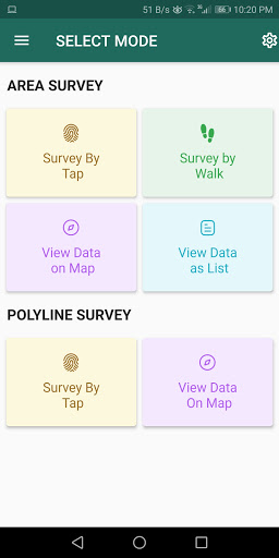
Free application for carrying out GIS survey. This app enables surveyors to collect data (coordinates) of points on a map by creating polygons/poly-lines. This can be done in two ways. First, by walking around the area of interest, or secondly, through manual selection of an area on the map.
Features:
1. Survey can be carried out using any of the two modes:
a. First survey mode (walking mode) can be used by surveyors for collecting several points by walking around the field/land or any region of interest. Polygon will be drawn on the map once survey of field is stopped by the surveyor.
b. Second survey mode (manual selection) can be used by surveyors for collecting several points by tapping on the map. Polygon/poly-line will be drawn on the map once surveyor stops selecting points on the map.
2. Each polygon can be listed under main-category(survey) and subcategory(class) for better organization of survey data.
3. Each polygon can be titled/named separately by surveyor.
4. Data can be viewed by any of two choices:
a. View data on map - Polygons/poly-lines can be viewed on map by selecting a "survey" name and a "class" name.
b. View data without map - Data of polygons can be viewed without map if user does not want to plot polygons on map and only wants to view data of the polygons.
5. Export and Share - Export and share data in json format.
6. Limit Constraint - This free version of app has a limit constraint of creating 20 polygons/poly-lines for any "class" of any "survey". However, new "classes" can be creating for carrying out survey.
7. Cloud storage - Data is stored in and synced with cloud.
- User can now download entire survey(s) data in json format- "Survey by Tap" for polygons, now show the previous polygons drawn by the users. This can now omit the possibility of drawing overlapping polygons.
Show moreRELATED