Copyright ©APK4Share. All Rights Reserved
Download Bewegungsradius Deutschland - v1.0.6
| Package Name | com.planlauf.bewegungsradius |
|---|---|
| Category | APPS, Map & Navigation |
| Latest Version | 1.0.6 |
| Get it On |

|
| Update | January 21, 2021 (4 years ago) |
There are quite a few APPS as good as
Sygic GPS Navigation & Maps v20.8.12-1769 APK + MOD (Premium Subscription)
MOD APK, Locus Map Pro Outdoor GPS navigation and maps APK Paid MOD APK, Lalamove Driver - Earn Extra Income, GPS Emulator Pro APK v1.59 MOD APK, Wikiloc Outdoor Navigation GPS Premium APK MOD APK, Hammer Truck GPS Navigation App, Maps, & Routes, and Bewegungsradius Deutschland - v1.0.6 too, one of the great APPS of the genre Map & Navigation.
Developed by planlauf GmbH, Bewegungsradius Deutschland - v1.0.6 requires Android version at least Android 5.1+. Therefore you must update your phone if necessary.
Bewegungsradius Deutschland - v1.0.6 APK latest version is 1.0.6, release date 2021-01-20, and has size 11.4 MB.
Statistics about 1000 downloads are available from Google Play. You can update apps that have been downloaded or installed individually on your Android device if you want. Updating your apps gives you more. access to the latest features and improve the security and stability of the application.
Because not all games or apps are compatible for all phones. And the game or application is sometimes unavailable for your device, it depends on the Android OS version, screen resolutions or countries that Google Play allows access to. So at APK4Share you can easily download APK files and not be subject to these restrictions.
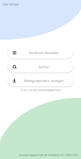
Die App 'Bewegungsradius' kann für alle Städte und Gemeinden in Deutschland den 15-km-Bewegungsradius auf einer Karte darstellen. Die maximale Entfernung von 15 km bezieht sich dabei auf die Gemeindegrenze und nicht auf den Wohnort.
Nach der Auswahl eines Bundeslandes kann nach dem Namen der Stadt oder Gemeinde gesucht werden. Durch die Eingabe der ersten Buchstaben kann die Auswahl in der Liste vereinfacht werden. Durch Antippen von Bewegungsradius anzeigen wird die Karte mit der Gemeindefläche und dem 15-km-Bewegungsradius angezeigt. Zur Darstellung der Karte wird Google Maps verwendet.
Falls gewünscht, kann der aktuelle Standort mit Hilfe von GPS angezeigt werden. Der Standort wird dabei grün dargestellt, wenn man sich innerhalb des 15-km-Bewegungsradius aufhält. Ein rotes Standortsymbol bedeutet, dass man den Bewegungsradius überschritten hat.
In dieser Version wird die Darstellung eines festen 15 km Radius um einen Mittelpunkt ergänzt:1) Auswahlmenü für die Grenzen aufrufen (in der Karte oben links) 2) Auf 'Festlegen' tippen und die Karte so bewegen und zoomen, dass der gewünschte Mittelpunkt unter dem blauen Fadenkreuz liegt.3) Auf 'Mittelpunkt festlegen' tippen.
Show more