Copyright ©APK4Share. All Rights Reserved
Download SkyDemon - v3.14.5
| Package Name | aero.skydemon.skydemonandroid |
|---|---|
| Category | APPS, Karten & Navigation |
| Latest Version | 3.14.5 |
| Get it On |

|
| Update | October 27, 2020 (5 years ago) |
Es gibt einige APPS so gut wie Locus Map Pro Outdoor GPS navigation and maps APK Paid MOD APK, GPS Emulator Pro APK v1.59 MOD APK,
Sygic GPS Navigation & Maps v20.8.12-1769 APK + MOD (Premium Subscription)
MOD APK, Relief Maps - 3D GPS Hiking | Trail Running | Ski, Bykea Partner, Genius Maps Offline GPS Navigation und SkyDemon - v3.14.5 auch eine der großen APPS des Genres Karten & Navigation.
Für SkyDemon - v3.14.5 entwickelt, erfordert SkyDemon - v3.14.5 mindestens eine Android-Version Android 4.0.3+. Daher müssen Sie Ihr Telefon bei Bedarf aktualisieren.
SkyDemon - v3.14.5 APK neueste Version ist 3.14.5, Erscheinungsdatum 2020-10-26 und hat Größe 39.3 MB.
Statistiken zu 1000 -Downloads sind bei Google Play erhältlich. Sie können Apps aktualisieren, die einzeln auf Ihr Android-Gerät heruntergeladen oder installiert wurden, wenn Sie möchten. Durch das Aktualisieren Ihrer Apps erhalten Sie mehr Zugriff auf die neuesten Funktionen und können die Sicherheit verbessern Stabilität der Anwendung.
Da nicht alle Spiele oder Apps für alle Telefone kompatibel sind. Und das Spiel oder die Anwendung für Ihr Gerät nicht verfügbar ist, hängt von der Android-Betriebssystemversion, den Bildschirmauflösungen oder den Ländern ab, auf die Google Play Zugriff gewährt. Bei APK4Share können Sie dies also tun Laden Sie einfach APK-Dateien herunter und unterliegen Sie nicht diesen Einschränkungen.
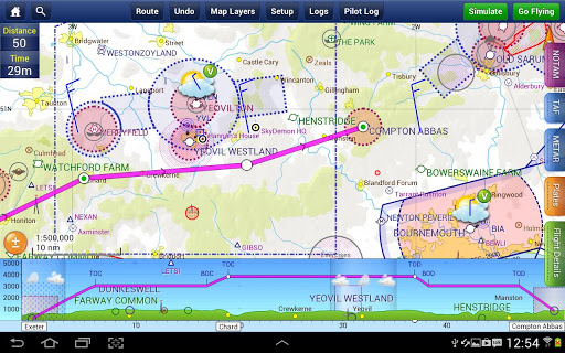
SkyDemon is one of Europe's most popular solutions for VFR flight planning and in-flight navigation.
Use this app to access your SkyDemon subscription on your Android device, unlocking SkyDemon's powerful features while on the move.
FLIGHT PLANNING FEATURES
- SkyDemon vector charts are the clearest aeronautical charts you'll ever use, with dynamic airspace clipping and choice of map layers
- Route planning is as simple as touching consecutive waypoints and dragging to make changes
- Virtual Radar shows how your route relates to airspace, terrain, obstructions and other features
- Pilot Log facility calculates headings and groundspeeds from actual wind data, and shows useful frequencies
- Plates and other documents for relevant airfields are displayed automatically as you plan, and many are available georeferenced for use in flight
- Intuitive pan, pinch and rotate support with no loss of map clarity or text legibility
- File a VFR flightplan for your route directly to air traffic controllers
- Automatic TAF, METAR and SIGMET briefing as you plan a route, with graphical decoding
- Rainfall data can be overlaid on the main map, with animation, showing the trend of rainfall over time
- Integration of GAFOR route forecasts for Switzerland, Austria, Slovenia and Croatia
- Both narrow-route and area NOTAM briefings available, updated as you plan
- Advanced NOTAM graphical interpretation and depiction on the main map
- Easily print your PLOG and the output from various briefings
- Warnings for airspace and other potential hazards to your flight, updated in real time
- Airfield Admin Information shows useful contacts and other details for airfields featured in our charts
- Forecast winds aloft are automatically retrieved for the flight time and displayed on the map
- Create an advanced flight performance profile for each aircraft you use
- ATS Routes mode offers an alternative chart presentation for flight along airways
- Accurate fuel, weight and balance calculations including flight costings
- Create an unlimited number of user-defined waypoints
- Analyse your track logs for posterity
- Choose between six different vector chart styles
- Extensive European chart coverage as standard
GPS NAVIGATION FEATURES
- Intelligent warnings for approaching airspace, NOTAM, obstacles, terrain and other hazards
- Virtual Radar shows a side-on projection of all approaching features and how your trajectory relates to them
- Vector map automatically follows the aircraft in north up, track up or course up orientation
- Clear and concise instruments show you flight statistics and help keep you on track
- An HSI/ILS instrument helps you keep to your planned route and line up early for approach
- Live Pilot Log shows progress through your route, ETAs, ATAs and useful frequencies based on your current position
- TerrainSafe dynamically colours mountainous terrain around you to quickly identify safer areas
- Direct To allows easy re-routing in a hurry by picking from a selection of nearby airfields
- Approach Information shows runway diagrams, TAF, METAR, NOTAM and other airfield details useful for making an approach
- Live updates of TAF and METAR while in flight, with associated alerts*
- Extended runway centrelines appear automatically on the map as you near your destination airfield
- Permanent display of position relative to nearest well-known waypoint, for position reporting
- Easy changing of the planned route while in flight by touching and dragging
* Internet connection required for live weather update while in flight
- Airspace Use Plan (AUP) data is now integrated into SkyDemon
Show more