Copyright ©APK4Share. All Rights Reserved
Descargar TouchTrails - Route Planner, GPX Viewer/Editor - v2.2.1
| Package Name | com.wolfgangknecht.sketchatrack |
|---|---|
| Category | Aplicaciones, Mapas y navegación |
| Latest Version | 2.2.1 |
| Get it On |

|
| Update | November 18, 2020 (5 years ago) |
Hay bastantes Aplicaciones tan buenos como Lalamove Driver - Earn Extra Income, Genius Maps Offline GPS Navigation, Radarbot (MOD, Premium Desbloqueado) MOD APK, Wikiloc Outdoor Navigation GPS Premium APK MOD APK, Hammer Truck GPS Navigation App, Maps, & Routes, Circuit Route Planner, y TouchTrails - Route Planner, GPX Viewer/Editor - v2.2.1 también, uno de los mejores Aplicaciones del género Mapas y navegación.
Desarrollado por pixelclash, TouchTrails - Route Planner, GPX Viewer/Editor - v2.2.1 requiere la versión de Android al menos Android 5.0+. Por lo tanto, debe actualizar su teléfono si es necesario.
TouchTrails - Route Planner, GPX Viewer/Editor - v2.2.1 APK la última versión es 2.2.1, la fecha de lanzamiento 2020-11-17 y el tamaño 17.1 MB.
Las estadísticas sobre 1000 descargas están disponibles en Google Play. Si lo desea, puede actualizar las aplicaciones que se han descargado o instalado individualmente en su dispositivo Android. Actualizar sus aplicaciones le brinda más. Acceso a las funciones más recientes y mejora la seguridad y estabilidad de la aplicación.
Debido a que no todos los juegos o aplicaciones son compatibles con todos los teléfonos. Y el juego o la aplicación no está disponible para tu dispositivo, depende de la versión del sistema operativo Android, las resoluciones de pantalla o los países a los que Google Play permite el acceso. Por lo tanto, en APK4Share puedes descargar archivos APK fácilmente y no estar sujeto a estas restricciones.
TouchTrails is an easy to use route planner. Measure the distance of your last running activity or explore the elevation profile of the next bike tour you are planning to do. Just draw it on the map and get the information you're looking for.
TouchTrails is the perfect route planner for all kind of outdoor activities, including:
• Hiking
• Cycling
• Mountain Bike
• Running
• Walking
• Mantrailing
With this route planner you can simply draw routes with your finger on the map. Get distance information and elevation profiles even for the smallest footpaths and trails in the backcountry.
You can split tracks, erase parts of a track or connect routes. Export your routes as GPX, share them and open them wherever you want to.
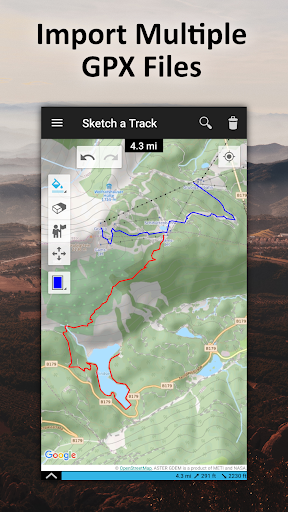
GPX Viewer
You can also use TouchTrails as a simple GPX viewer. Import gpx files for your hiking tour or whatever outdoor activity you plan to do. Multiple routes will be displayed in different colors. Measure distances and view elevation profiles.
Features
• Route planner - draw routes with finger
• GPX Viewer - import GPX files
• Explore elevation profiles
• Calculate distances
• Manage and merge multiple routes
Pro Features
• Save as many tracks as you want
• Export gpx files
• Generate offline maps for your backcountry trip
Install TouchTrails–the route planner at your fingertip–to plan your next hiking or mountain bike tour on a small footpath in the backcountry now ?.
• New map provider: faster and more reliable maps
Show more