Copyright ©APK4Share. All Rights Reserved
Descargar NavShip - Boat Navigation (USA & Europe) - v1.31.1
| Package Name | de.cprosoft.navship |
|---|---|
| Category | Aplicaciones, Mapas y navegación |
| Latest Version | 1.31.1 |
| Get it On |

|
| Update | February 18, 2021 (4 years ago) |
Hay bastantes Aplicaciones tan buenos como Hammer Truck GPS Navigation App, Maps, & Routes, GPS Emulator Pro APK v1.59 MOD APK, Genius Maps Offline GPS Navigation, Bykea Partner, Locus Map Pro Outdoor GPS navigation and maps APK Paid MOD APK, Radarbot (MOD, Premium Desbloqueado) MOD APK, y NavShip - Boat Navigation (USA & Europe) - v1.31.1 también, uno de los mejores Aplicaciones del género Mapas y navegación.
Desarrollado por CproSoft GmbH, NavShip - Boat Navigation (USA & Europe) - v1.31.1 requiere la versión de Android al menos Android 4.1+. Por lo tanto, debe actualizar su teléfono si es necesario.
NavShip - Boat Navigation (USA & Europe) - v1.31.1 APK la última versión es 1.31.1, la fecha de lanzamiento 2021-02-17 y el tamaño 21.5 MB.
Las estadísticas sobre 1000 descargas están disponibles en Google Play. Si lo desea, puede actualizar las aplicaciones que se han descargado o instalado individualmente en su dispositivo Android. Actualizar sus aplicaciones le brinda más. Acceso a las funciones más recientes y mejora la seguridad y estabilidad de la aplicación.
Debido a que no todos los juegos o aplicaciones son compatibles con todos los teléfonos. Y el juego o la aplicación no está disponible para tu dispositivo, depende de la versión del sistema operativo Android, las resoluciones de pantalla o los países a los que Google Play permite el acceso. Por lo tanto, en APK4Share puedes descargar archivos APK fácilmente y no estar sujeto a estas restricciones.
Best for inland waterway routing! Please note, that some rivers and seas might not be included yet. Please use the contact form inside the app menu (report error at the bottom) to request a new waterway, and we will implement them as soon as possible.
Free version: Up to 40 km (25 miles) route planning and 8 km tracking. We use advertisement in free version.
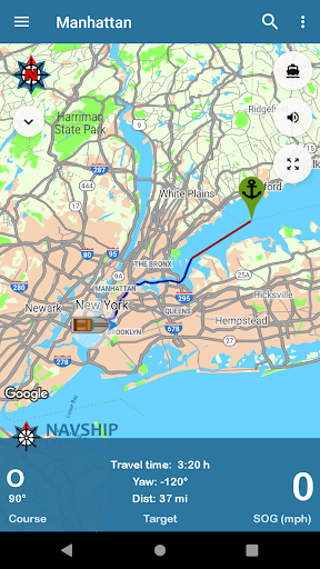
NavShip is a free navigation assistance software for nautic usage in Europe, Canada and the United States. It uses an special overlay for google maps or open sea map to show shipping signs and contains by now more than 250.000 waterways.
No problem to get from A to B, even if there's an ocean between you and your target. London - Rome, Paris - Amsterdam, Copenhagen - Stockholm, Frankfurt - Istanbul, Chicago - Toronto, nearly every route can be calculated.
NavShip needs access to device's storage to work properly. It never accesses your private data or contacts.
WEAR OS: NavShip provides a Wear OS App for Smartwatches. You can easily connect with live routing on your app. Calculate a route on your smartphone and view your current speed, course offset, distance and travel time via smartwatch. Even the next bridge or lock will be displayed.
Features:
Offline-Routing
Live-Routing
Kilometres or miles, km/h or knots
Travel time and distance
Approx. arrival time
Course and speed over ground
Locks
Fuel and costs
Anchor alert
Implementation of own boat icon for routing
Lots of more...
Get more information at www.navship.org
Disclaimer: This app should only be used as an assistant. Please use it carefully and supportive. NavShip is not responsible for accidents. Please note the in app disclaimer and the terms of use at navship.org.
Added side menu entry for privacy policyNew menu entry to swap start and finishCurrents in bodies of water are taken into account if it has been activated in the app settings (currently only for Rhine, Main, Neckar, Mosel, Waal, Lek, IJssel, Maas, Odra, Weser, Elbe, Lahn, Danube and Ems)The app warns when the current of a river is greater than the maximum speed of the boatAdded new compass imageUpdated translations
Show more