Copyright ©APK4Share. All Rights Reserved
Téléchargement Geo Survey - v1.1
| Package Name | com.ncbc.survey.gis |
|---|---|
| Category | Applications, Plans et navigation |
| Latest Version | 1.1 |
| Get it On |

|
| Update | February 08, 2021 (4 years ago) |
Il y en a pas mal de Applications aussi bons que Genius Maps Offline GPS Navigation, Hammer Truck GPS Navigation App, Maps, & Routes, Radarbot (MOD, Premium Déverrouillé) MOD APK, Jugnoo Drivers, Circuit Route Planner, Wikiloc Outdoor Navigation GPS Premium APK MOD APK et Geo Survey - v1.1 aussi l'un des meilleurs Applications du genre Plans et navigation.
Développé par National Center for Big Data and Cloud Computing, Geo Survey - v1.1 nécessite au moins la version Android Android 4.1+. Par conséquent, vous devez mettre à jour votre téléphone si nécessaire.
Geo Survey - v1.1 APK la dernière version est le 1.1, la date de sortie 2021-02-07 et la taille 7.9 MB.
Les statistiques sur 1000 téléchargements sont disponibles sur Google Play. Vous pouvez mettre à jour les applications qui ont été téléchargées ou installées individuellement sur votre appareil Android si vous le souhaitez. La mise à jour de vos applications vous donne davantage.accéder aux dernières fonctionnalités et améliorer la sécurité et stabilité de l'application.
Tous les jeux ou applications ne sont pas compatibles avec tous les téléphones. Et le jeu ou l'application n'est pas disponible pour votre appareil, cela dépend de la version du système d'exploitation Android, des résolutions d'écran ou des pays auxquels Google Play autorise l'accès. Donc, sur APK4Share, vous pouvez téléchargez facilement des fichiers APK et ne soyez pas soumis à ces restrictions.
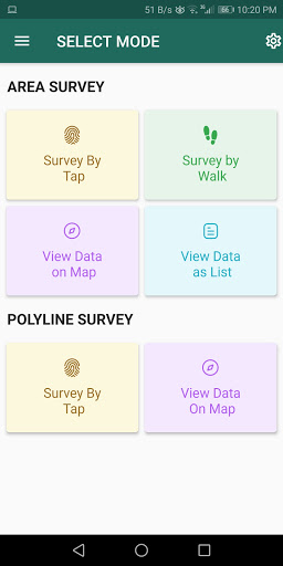
Free application for carrying out GIS survey. This app enables surveyors to collect data (coordinates) of points on a map by creating polygons/poly-lines. This can be done in two ways. First, by walking around the area of interest, or secondly, through manual selection of an area on the map.
Features:
1. Survey can be carried out using any of the two modes:
a. First survey mode (walking mode) can be used by surveyors for collecting several points by walking around the field/land or any region of interest. Polygon will be drawn on the map once survey of field is stopped by the surveyor.
b. Second survey mode (manual selection) can be used by surveyors for collecting several points by tapping on the map. Polygon/poly-line will be drawn on the map once surveyor stops selecting points on the map.
2. Each polygon can be listed under main-category(survey) and subcategory(class) for better organization of survey data.
3. Each polygon can be titled/named separately by surveyor.
4. Data can be viewed by any of two choices:
a. View data on map - Polygons/poly-lines can be viewed on map by selecting a "survey" name and a "class" name.
b. View data without map - Data of polygons can be viewed without map if user does not want to plot polygons on map and only wants to view data of the polygons.
5. Export and Share - Export and share data in json format.
6. Limit Constraint - This free version of app has a limit constraint of creating 20 polygons/poly-lines for any "class" of any "survey". However, new "classes" can be creating for carrying out survey.
7. Cloud storage - Data is stored in and synced with cloud.
- User can now download entire survey(s) data in json format- "Survey by Tap" for polygons, now show the previous polygons drawn by the users. This can now omit the possibility of drawing overlapping polygons.
Show more