
Copyright ©APK4Share. All Rights Reserved
Ce ne sono alcuni App buoni come R.B.I Baseball 20 Mod (Versione completa) + Data v1.0.5 MOD APK, MotoGP™, (FPL) Fantasy Football Manager for Premier League, StraMi - Upload Mi band heart rate data to Strava,
Cricbuzz v5.03.11 APK + MOD (ADS Removed) Download
MOD APK, Thop TV : Live Cricket TV Streaming, thoptv e PPGpS Lite - v1.55 anche uno dei migliori App del genere Sports.
Sviluppato da NS31 Software, PPGpS Lite - v1.55 richiede almeno la versione Android Android 4.0+. Pertanto è necessario aggiornare il telefono se necessario.
PPGpS Lite - v1.55 APK l'ultima versione è 1.55, data di rilascio 2020-09-19 e dimensioni 2.8 MB.
Le statistiche sui download di 1000 sono disponibili da Google Play. Se lo desideri, puoi aggiornare le app che sono state scaricate o installate singolarmente sul tuo dispositivo Android. L'aggiornamento delle tue app ti dà più accesso alle funzioni più recenti e migliora la sicurezza e stabilità dell'applicazione.
Perché non tutti i giochi o le app sono compatibili con tutti i telefoni. E il gioco o l'applicazione non è disponibile per il tuo dispositivo, dipende dalla versione del sistema operativo Android, dalle risoluzioni dello schermo o dai paesi a cui Google Play consente l'accesso. Quindi su APK4Share puoi scarica facilmente i file APK e non essere soggetto a queste restrizioni.
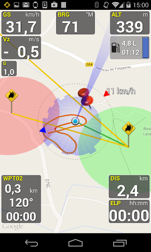
Flight Computer for Paramotor, Paraglider, Glider and Ultra Light plane Pilots
Welcome to PPGpS, a Flight Computer for Paramotor, Paraglider, Glider and Ultra Light plane Pilots
*WARNING there are missing features in the Lite version:
-Log flights in KML/IGC format
-Waypoints management
-Airspace display
-QNH/QFE altimeter setting
-Android Wear smartwatches via PPGpS Wear compatibility
-The annoying popups are removed in the Full version
-Display instruments on your Android Wear SmartWatch
*FEATURES OVERVIEW:
-Real time flight information
-Wind direction and speed estimation
-Takeoff and Landing phases auto-detection
-Return home information (display estimated travel time and bearing)
-Fuel calculation and warning
-Airspace display (OpenAir files)
-Emergency geo-localized SMS
-Localization with GPS
-Barometric sensor support to improve altitude accuracy
-QHN, QFE Altimeter setting
-Online and offline maps
-Offline maps creator
-Google Maps and OpenStreetMap map providers
-Rotating Map
-Log flights in KML (for Google Earth), IGC (Leonardo servers) and GPX files
-Replay recorded flights
-Waypoint management
-Especially developed for Paramotor
-Embedded User Manual and Tip of the day feature.
-Real time flight tracking on www.ppgps.info
-Variometer
-Sunset time
-FlyNet2, Flight Bandit, BlueFlyVario variometer support
-Android Wear SmartWatch support with PPGpS Wear
*MAPS:
Online:
PPGpS can display Google or OpenStreetMap maps in connected mode.
Offline:
Download map files in your smartphone in case you don't have an internet connection during the flight.
Use the integrated PPGpS Offline Map Creator to generate offline maps.
*INSTRUMENTS:
PPGpS provides the altitude, vario, bearing, magnetic compass, acceleration and ground speed.
With just one click on instruments you switch easily between different data modes : instantaneous, average and maximum values.
Altimeter can be set to actual altitude or elevation (QHN, QFE) just by long-pressing on the altimeter.
If your smartphone has a barometric sensor, it could be used to compute a very accurate altitude.
You can use PPGpS Wear companion application to display your instruments on your SmartWatch.
*WAYPOINTS:
Create waypoints by tapping on the map or by entering their GPS coordinates.
Select a waypoint with one click on the waypoint instrument (WPT).
Rename or remove a waypoint from the contextual menu of the waypoint list.
Follow the displayed route (bearing, estimated travel time and distance).
Prepare your waypoints from Google Earth and import your KML files (PPGpS folder in the phone).
Waypoints may be automatically loaded at startup and saved at the end of the session.
In case your KML file doesn't import well, please send me the file and I will fix it quickly.
*WIND AND SPEEDS HUD:
The average ground speeds are graphically displayed for every azimuth.
The wind direction is displayed (red arrow) and may be reset at any time during the flight.
*RETURN HOME:
Home direction and Estimated Travel Time to return home is always displayed (shaded red line).
Computations are done according to the wind for accurate results.
*LIVE TRACKING:
Enable the Live Tracking feature to allow your friends and family to see you live on map ! Go to www.ppgps.info for more details.
*AIRSPACE:
Copy OpenAir files in the /ppgps/airspace folder to display airspaces on top of the map
Use my other app AirspaceMap to help you download and customize your openAir files
https://play.google.com/store/apps/details?id=com.ns31.airspacemap
Launch the Demonstration mode to have a quick tour.
Visit http://www.ppgps.info
Find us on Facebook : https://www.facebook.com/ppgps
and Twitter : https://twitter.com/PPGpSAndroid
Enjoy your flights with PPGpS and thank you for your feedback.
Don't hesitate to send me your kml flight logs by mail : [email protected]
1.55 09/2020Configurable cockpit layout fixedOpenStreetMap provider fixedOpenTopoMap provider addedAndroid 10 compatibility fixesLarge text settings issue fixedLock the screen in portrait or landscapeSet QHN and QFE in hPaCompatibility with BluflyVario latest firmwareUse bluetooth variometers for altitudeUnified selection for altimeter and variometer providersAdded a close button on the "Tip of the day" window
Show more