Copyright ©APK4Share. All Rights Reserved
Scarica Biggerworks Nautical Maps - v7.0.0
| Package Name | nl.anwb.android.anwbwaterkaarten |
|---|---|
| Category | App, Viaggi e info locali |
| Latest Version | 7.0.0 |
| Get it On |

|
| Update | January 20, 2021 (4 years ago) |
Ce ne sono alcuni App buoni come PeakFinder Mod Extra APK Paid Patched MOD APK, GoPartner, clever-tanken.de, KKFly.hk, Outdooractive | Welcome home, Patel Tours & Travels e Biggerworks Nautical Maps - v7.0.0 anche uno dei migliori App del genere Viaggi e info locali.
Sviluppato da Biggerworks, Biggerworks Nautical Maps - v7.0.0 richiede almeno la versione Android Android 6.0+. Pertanto è necessario aggiornare il telefono se necessario.
Biggerworks Nautical Maps - v7.0.0 APK l'ultima versione è 7.0.0, data di rilascio 2021-01-19 e dimensioni 56.3 MB.
Le statistiche sui download di 1000 sono disponibili da Google Play. Se lo desideri, puoi aggiornare le app che sono state scaricate o installate singolarmente sul tuo dispositivo Android. L'aggiornamento delle tue app ti dà più accesso alle funzioni più recenti e migliora la sicurezza e stabilità dell'applicazione.
Perché non tutti i giochi o le app sono compatibili con tutti i telefoni. E il gioco o l'applicazione non è disponibile per il tuo dispositivo, dipende dalla versione del sistema operativo Android, dalle risoluzioni dello schermo o dai paesi a cui Google Play consente l'accesso. Quindi su APK4Share puoi scarica facilmente i file APK e non essere soggetto a queste restrizioni.
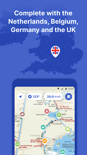
Biggerworks Nautical Maps is the most complete app on the Dutch waters. With ANWB Almanac 2, water maps, marinas, bridges, locks, route planner, offline use and more. Try now and plan your next trip!
With the Nautical Maps app you have everything you need at hand:
• 4 countries, 1 price: Complete nautical maps of the Netherlands, Belgium, Germany and the United Kingdom
• Consult all information from the paper ANWB Water Almanac 2 with just a few taps in the app
• All current information about marinas, bridges and locks including opening times
• Plan the optimal route between your starting point and destination, including the objects you encounter (beta)
• Show or hide information on the nautical maps to see exactly what you need
• Stay up-to-date with the current navigation reports and obstructions from the Rijkswaterstaat
• More than 200,000 nautical objects (bridges, locks, markings, mooring places and more)
• Locations of more than 4,000 marinas and all details of existing facilities
• Radio silence on the water? No problem! Download the corresponding charts for offline use
• Regular updates and free access to all new features
• Each user account can be used on up to 3 devices at no extra cost
• Free Windows version included with the annual subscription
• Reliable service: We are at your service 7 days a week ([email protected])
How the subscription works:
Nautical Maps is free for the first 7 days. After that, the app only works with a valid subscription. You can purchase the following subscriptions:
• Monthly subscription (€ 12.99)
• Seasonal subscription (3 months for just € 29.99)
• Annual subscription including the free Windows version (€ 42.99)
The subscription ends automatically.
Please note: If you purchase a subscription during the free 7-day trial period, the rest of the trial period will expire. Your purchased subscription is not automatically renewed.
Payment methods for subscription
• The subscription will be charged to your Google account
• At Google you can use different payment methods for a subscription, such as PayPal or credit card
Even more boating pleasure with a Nautical Maps account
You can create an account in the app to activate your subscription on a total of 3 devices.
Note:
• The file size of the offline map material is very large and you are advised to download it on a stable Wi-Fi connection.
• Prolonged use of GPS in the background can considerably shorten the battery life of your device.
Do you have questions about the app? Please contact our help desk
([email protected]) or read more on our website (https://www.waterkaarten.app).
The 2021 version of the app is here!-The newest nautical maps with the latest information-Improved performance, the app is now faster and more stable-Improved routeplanner-The POI details are completely overhauled: now with reviews, photos and tips-New POIs: restaurants-Premium POIs-New information and data corrections-Several bug fixesWe wish all of our users a pleasant boating experience with the new version of Nautical maps. The most complete app to boat safely on the waterways.
Show moreOTHER VERSIONS
RELATED