Copyright ©APK4Share. All Rights Reserved
Скачать TouchTrails - Route Planner, GPX Viewer/Editor - v2.2.1
| Package Name | com.wolfgangknecht.sketchatrack |
|---|---|
| Category | приложения, Карты и навигация |
| Latest Version | 2.2.1 |
| Get it On |

|
| Update | November 18, 2020 (5 years ago) |
Есть довольно много приложения таких же хороших, как Lalamove Driver - Earn Extra Income, Locus Map Pro Outdoor GPS navigation and maps APK Paid MOD APK, Circuit Route Planner, Bykea Partner, Wikiloc Outdoor Navigation GPS Premium APK MOD APK,
Sygic GPS Navigation & Maps v20.8.12-1769 APK + MOD (Premium Subscription)
MOD APK, и TouchTrails - Route Planner, GPX Viewer/Editor - v2.2.1 тоже один из величайших приложения жанров Карты и навигация.
Разработано pixelclash, TouchTrails - Route Planner, GPX Viewer/Editor - v2.2.1 требует версии Android не ниже Android 5.0+. Поэтому при необходимости вы должны обновить свой телефон.
TouchTrails - Route Planner, GPX Viewer/Editor - v2.2.1 APK последняя версия - 2.2.1, дата выпуска 2020-11-17, размер 17.1 MB.
Статистические данные о загрузках 1000 доступны в Google Play. Вы можете обновлять приложения, которые были загружены или установлены по отдельности на вашем устройстве Android, если хотите. Обновление ваших приложений дает вам больший доступ к новейшим функциям и повышает безопасность и стабильность работы приложения.
Потому что не все игры и приложения совместимы со всеми телефонами. А игра или приложение недоступны для вашего устройства, это зависит от версии ОС Android, разрешения экрана или страны, к которой Google Play разрешает доступ. Так что на APK4Share вы можете легко загружать файлы APK и не подпадать под эти ограничения.
TouchTrails is an easy to use route planner. Measure the distance of your last running activity or explore the elevation profile of the next bike tour you are planning to do. Just draw it on the map and get the information you're looking for.
TouchTrails is the perfect route planner for all kind of outdoor activities, including:
• Hiking
• Cycling
• Mountain Bike
• Running
• Walking
• Mantrailing
With this route planner you can simply draw routes with your finger on the map. Get distance information and elevation profiles even for the smallest footpaths and trails in the backcountry.
You can split tracks, erase parts of a track or connect routes. Export your routes as GPX, share them and open them wherever you want to.
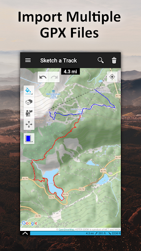
GPX Viewer
You can also use TouchTrails as a simple GPX viewer. Import gpx files for your hiking tour or whatever outdoor activity you plan to do. Multiple routes will be displayed in different colors. Measure distances and view elevation profiles.
Features
• Route planner - draw routes with finger
• GPX Viewer - import GPX files
• Explore elevation profiles
• Calculate distances
• Manage and merge multiple routes
Pro Features
• Save as many tracks as you want
• Export gpx files
• Generate offline maps for your backcountry trip
Install TouchTrails–the route planner at your fingertip–to plan your next hiking or mountain bike tour on a small footpath in the backcountry now ?.
• New map provider: faster and more reliable maps
Show more