Copyright ©APK4Share. All Rights Reserved
İndir Geo Survey - v1.1
| Package Name | com.ncbc.survey.gis |
|---|---|
| Category | Uygulamalar, Haritalar ve Navigasyon |
| Latest Version | 1.1 |
| Get it On |

|
| Update | February 08, 2021 (4 years ago) |
Uygulamalar
Sygic GPS Navigation & Maps v20.8.12-1769 APK + MOD (Premium Subscription)
MOD APK, Hammer Truck GPS Navigation App, Maps, & Routes, Wikiloc Outdoor Navigation GPS Premium APK MOD APK, Radarbot (MOD, Premium Kilitli) MOD APK, Jugnoo Drivers, Bykea Partner kadar iyi ve Geo Survey - v1.1 türün en iyilerinden Uygulamalar biri Haritalar ve Navigasyon var.
National Center for Big Data and Cloud Computing tarafından geliştirilmiştir, Geo Survey - v1.1 en az Android sürümünü gerektirir Android 4.1+. Bu nedenle, gerekirse telefonunuzu güncellemelisiniz.
Geo Survey - v1.1 APK en son sürüm 1.1, yayın tarihi 2021-02-07 ve boyutu 7.9 MB.
İndirmelerle ilgili 1000 istatistiklere Google Play'den ulaşabilirsiniz. Android cihazınıza tek tek indirilmiş veya yüklenmiş uygulamaları güncelleyebilirsiniz. Uygulamalarınızı güncellemek size en yeni özelliklere daha fazla erişim sağlar ve güvenliği ve uygulamanın kararlılığı.
Çünkü tüm oyunlar veya uygulamalar tüm telefonlar için uyumlu değildir. Ve oyun veya uygulama cihazınız için kullanılamaz, bu Android işletim sistemi sürümüne, ekran çözünürlüklerine veya Google Play'in erişime izin verdiği ülkelere bağlıdır. Yani APK4Share'de şunları yapabilirsiniz APK dosyalarını kolayca indirin ve bu kısıtlamalara tabi olmayın.
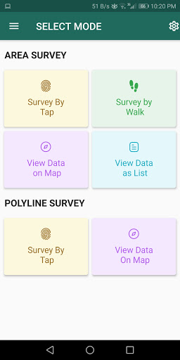
Free application for carrying out GIS survey. This app enables surveyors to collect data (coordinates) of points on a map by creating polygons/poly-lines. This can be done in two ways. First, by walking around the area of interest, or secondly, through manual selection of an area on the map.
Features:
1. Survey can be carried out using any of the two modes:
a. First survey mode (walking mode) can be used by surveyors for collecting several points by walking around the field/land or any region of interest. Polygon will be drawn on the map once survey of field is stopped by the surveyor.
b. Second survey mode (manual selection) can be used by surveyors for collecting several points by tapping on the map. Polygon/poly-line will be drawn on the map once surveyor stops selecting points on the map.
2. Each polygon can be listed under main-category(survey) and subcategory(class) for better organization of survey data.
3. Each polygon can be titled/named separately by surveyor.
4. Data can be viewed by any of two choices:
a. View data on map - Polygons/poly-lines can be viewed on map by selecting a "survey" name and a "class" name.
b. View data without map - Data of polygons can be viewed without map if user does not want to plot polygons on map and only wants to view data of the polygons.
5. Export and Share - Export and share data in json format.
6. Limit Constraint - This free version of app has a limit constraint of creating 20 polygons/poly-lines for any "class" of any "survey". However, new "classes" can be creating for carrying out survey.
7. Cloud storage - Data is stored in and synced with cloud.
- User can now download entire survey(s) data in json format- "Survey by Tap" for polygons, now show the previous polygons drawn by the users. This can now omit the possibility of drawing overlapping polygons.
Show more