Copyright ©APK4Share. All Rights Reserved
İndir TouchTrails - Route Planner, GPX Viewer/Editor - v2.2.1
| Package Name | com.wolfgangknecht.sketchatrack |
|---|---|
| Category | Uygulamalar, Haritalar ve Navigasyon |
| Latest Version | 2.2.1 |
| Get it On |

|
| Update | November 18, 2020 (4 years ago) |
Uygulamalar Circuit Route Planner, Bykea Partner, Jugnoo Drivers, Relief Maps - 3D GPS Hiking | Trail Running | Ski, Locus Map Pro Outdoor GPS navigation and maps APK Paid MOD APK, Radarbot (MOD, Premium Kilitli) MOD APK kadar iyi ve TouchTrails - Route Planner, GPX Viewer/Editor - v2.2.1 türün en iyilerinden Uygulamalar biri Haritalar ve Navigasyon var.
pixelclash tarafından geliştirilmiştir, TouchTrails - Route Planner, GPX Viewer/Editor - v2.2.1 en az Android sürümünü gerektirir Android 5.0+. Bu nedenle, gerekirse telefonunuzu güncellemelisiniz.
TouchTrails - Route Planner, GPX Viewer/Editor - v2.2.1 APK en son sürüm 2.2.1, yayın tarihi 2020-11-17 ve boyutu 17.1 MB.
İndirmelerle ilgili 1000 istatistiklere Google Play'den ulaşabilirsiniz. Android cihazınıza tek tek indirilmiş veya yüklenmiş uygulamaları güncelleyebilirsiniz. Uygulamalarınızı güncellemek size en yeni özelliklere daha fazla erişim sağlar ve güvenliği ve uygulamanın kararlılığı.
Çünkü tüm oyunlar veya uygulamalar tüm telefonlar için uyumlu değildir. Ve oyun veya uygulama cihazınız için kullanılamaz, bu Android işletim sistemi sürümüne, ekran çözünürlüklerine veya Google Play'in erişime izin verdiği ülkelere bağlıdır. Yani APK4Share'de şunları yapabilirsiniz APK dosyalarını kolayca indirin ve bu kısıtlamalara tabi olmayın.
TouchTrails is an easy to use route planner. Measure the distance of your last running activity or explore the elevation profile of the next bike tour you are planning to do. Just draw it on the map and get the information you're looking for.
TouchTrails is the perfect route planner for all kind of outdoor activities, including:
• Hiking
• Cycling
• Mountain Bike
• Running
• Walking
• Mantrailing
With this route planner you can simply draw routes with your finger on the map. Get distance information and elevation profiles even for the smallest footpaths and trails in the backcountry.
You can split tracks, erase parts of a track or connect routes. Export your routes as GPX, share them and open them wherever you want to.
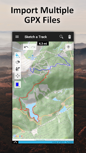
GPX Viewer
You can also use TouchTrails as a simple GPX viewer. Import gpx files for your hiking tour or whatever outdoor activity you plan to do. Multiple routes will be displayed in different colors. Measure distances and view elevation profiles.
Features
• Route planner - draw routes with finger
• GPX Viewer - import GPX files
• Explore elevation profiles
• Calculate distances
• Manage and merge multiple routes
Pro Features
• Save as many tracks as you want
• Export gpx files
• Generate offline maps for your backcountry trip
Install TouchTrails–the route planner at your fingertip–to plan your next hiking or mountain bike tour on a small footpath in the backcountry now ?.
• New map provider: faster and more reliable maps
Show more